List of currently known data sources.
| Location | Source | Description | Date Range | Curator | External Source | Status | Links | Issues |
|---|---|---|---|---|---|---|---|---|
| Big Ditch, Camp Creek, Goose Creek, Goose Creek at Bucks Pond, Saybrook, Wildcat | HOBO | An additional stream was created for Goose Creek at Bucks Pond and Saybrook. These two locations have air sensors and water sensors, and a calculation is performed from these two measurements that determines the water elevation. | 04/22/2014 - 07/6/2015 | Tim and Brynne from ISWS Mingjing Yu? | No | http://imlczo.ncsa.illinois.edu/clowder/collection/5500f98ce4b0feb5ae1545e7 |
| |
| Clear Creek | Eddy Flux Tower | Clear Creek 1-1, 2-1 | Christopher Wilson | No | See attached spreadsheet | There are two sites that light up for CCW-Z2-S1-EF1. The other one should be CCW-Z1-S1-EF1. | ||
| Clear Creek | Soil gas Analyzer | Clear Creek 1-1, 1-2, 2-1, 3-1 | Christopher Wilson | No | See attached spreadsheet | Part of ER experiments, still being processed for publication.
| ||
| Clear Creek | Rainfall Simulators | Clear Creek 1-1, 2-1 | Christopher Wilson | No | Part of ER experiments, still being processed for publication. | |||
| Clear Creek | Water Content Reflectrometer | Clear Creek 1-1, 2-1 | Christopher Wilson | No | Part of ER experiments, still being processed for publication. H | |||
| USRB | USGS Water Quality | Historical data ingested by Ye Fan. Not currently being updated.
| 2/2014-5/2014 | Nobody | Yes | Only on dashboard under USGS | ||
| Clear Creek | IFC River Sensors | CLRCRK01, CLRCRK03, CLRCRKS01, CLRCRKS02, CLRCRKW01 | 03/23/2014 - 10/13/2014 | Nobody | Yes | http://ifis.iowafloodcenter.org/ifis/en/ | ||
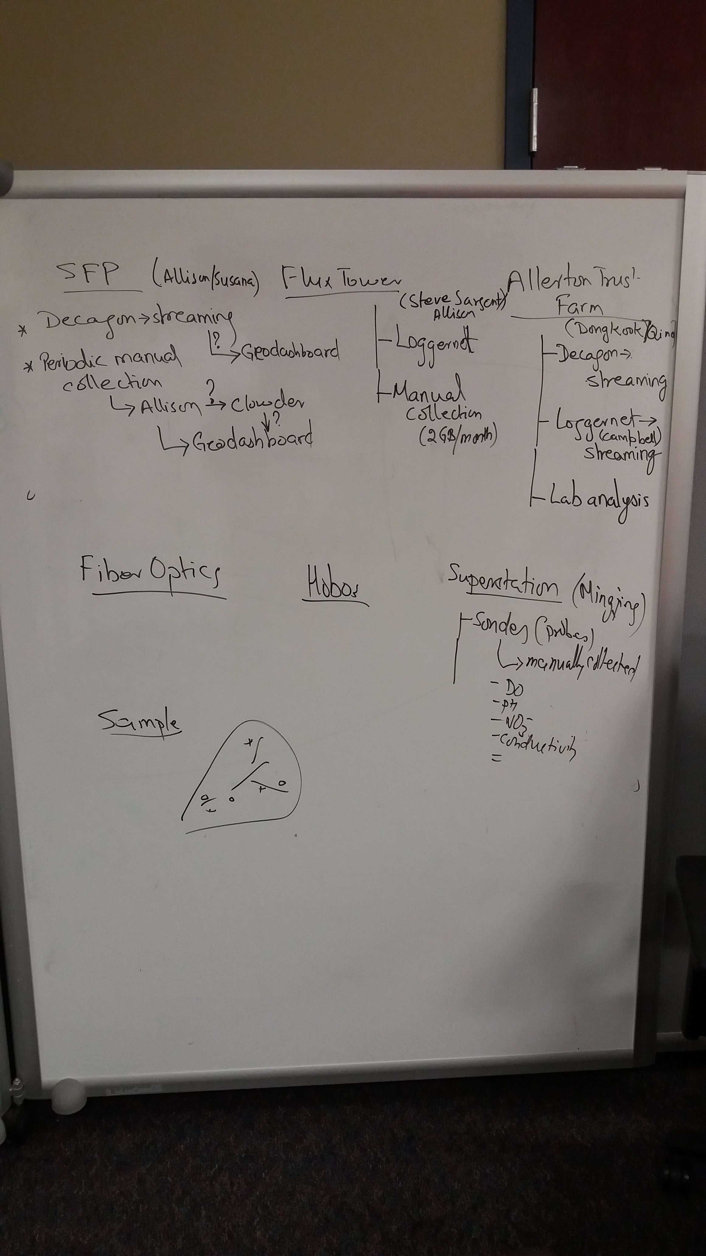
| Sangamon Forest Preserve | Decagon Manual upload | Latitude: 40.281513° Longitude: -88.355564° (approximate, from Google Earth) Parameters: Rainfall (mm), Relative Humidity, Solar Radiation (w/m2), windspeed (m/s), wind direction (degrees), Air temperature (deg C), Leaf wetness (1=wet/2=not wet). All parameters recorded at 1 minute interval. | Allison Goodwell | No | http://imlczo.ncsa.illinois.edu/clowder/spaces/572a0c83e4b0ed483bd5e41d http://imlczo-dev.ncsa.illinois.edu/geodashboard/#detail/location/SRFP |
| ||
| USRB | Flux Tower | Latitude: 40.15569444° Longitude: -88.55511111° Parameters: 25m tower. Instruments located at 3 heights: 25m, 10m, ground level. Infrared Temperature, Heat Flux, NDVI, PRI, Soil moisture/EC/Soil Temp, Wind speed, Photon Flux, CO2/H2O Flux, Radiation Flux | Steve Sargent Allison Goodwell Susana Roque | No |
| http://imlczo-dev.ncsa.illinois.edu/clowder/spaces/570e7d67e4b0ed483bd2da27 http://imlczo.ncsa.illinois.edu/clowder/spaces/570e7d67e4b0ed483bd2da27 Example geodashboard location (one of many): http://imlczo-dev.ncsa.illinois.edu/geodashboard/#detail/location/5TE Soil Probe 200cm/ |
| |
| Allerton Trust Farm | Latitude:40.025611° Longitude: -88.661167° (approximate from Google Earth) Parameters: This site is equipped with an ISCO to collect data from tile drains. Soil Moisture/Soil Temp/Soil EC, Water EC/Water Temp/Water Depth, Wind speed, Precipitation, Air Temp/Vapor Pressure/Relative Humidity, ISCO | Dongkook Woo Qina Yan | No |
| Decagon Datalogger : http://www.ech2o.com/ Username: 5G0F5179 Password: shwai-regi Campbell Datalogger: Installed |
| ||
| Ameriflux Bondville | Historical data from Aug-1996 - 12/31/2008.
| 1996-2008 | Brock Angelo | Yes |
| |||
| Illinois State Water Survey (ISWS) | Several historical sensors ingested. As of 2015, only ISWS105 at Mahomet and ISWS134 at Saybrook are being updated. These are added to a Samba share and are parsed hourly and added to the API. | Erin Bauer | No | |||||
| Illinois State Water Survey (ISWS) | Three locations of suspended sediment concentration collection through an ISCO Saybrook (40.437162°, -88.554961°) Mahomet (40.171096°, -88.446063°) Monticello (40.030936°, -88.588422°) All three locations use a 6712 Teledyne ISCO to collect samples. Also included are: Saybrook- CR850 datalogger, CS451 pressure transducer Mahomet- CR10X datalogger, CS475 water level indicator Monticello- 1640 liquid level actuator | Laura Keefer, Bruce Rhoads | No |
Need Data | ||||
| Illinois State Geological Survey (ISGS) | The fiber-optic distributed temperature sensing (FO-DTS) team at the ISGS is equipped with: 1. SensorNet Oryx+ Distributed Temperature Sensing (DTS) system [Travel in Truck] 2. Fujikura FS70 Fusion Splicer [Travel in Truck] 3. Brugg BRUsens Temperature 4-fiber cable: 1100m for in situ measurement [Travel in Truck] 4. MULTILINK AT-RK28T7X-004 2-fiber cable: 2500m for ditch bed deployment at flux tower site in 2015-2016 (40.15569444°, -88.55511111°) 5. AFL DNS-0763 Flat Drop 2-fiber cable: 104m for 40m well in Rantoul site (40.282582°, -88.193135°) 6. AFL DNS-0763 Flat Drop 2-fiber cable: 171m for 100m borehole in Rantoul site (40.282582°, -88.193135°) 7. AFL DNS-0763 Flat Drop 2-fiber cable: 1100m for in situ measurement [Travel in Truck] 8. AFL DNS-0763 Flat Drop 2-fiber cable: 325m experimental configuration for future deployment
9. One 240 volt and 2,000 watt cartridge heater with 100m cable is under construction at the ISGS for future heat tracer tests such fracture detection and groundwater/surface water interaction. | Yu-Feng Lin | No |
Need Data |
There are other data missing like our wells, weathering array and water quality sondes.
Are the pins sensors or sites? We entered more sensors in the past
I don't follow the Clear Creek catchment layer.
The CCW church sites looks off
Questions regarding raw data vs processed data. This is more for clowder..
How will you represent the baseline sampling or this experimental data which are more point measurements vs. time series
here is all the current sites and their data information