-
Task
-
Resolution: Fixed
-
 Normal
-
None
-
None
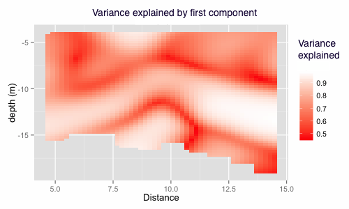
Global model (such as normal PCA) reveals global relations of variables, which is not good because lake have different properties along different depth and long/lat. A local model that can reveal the local features is better.
Geographically weighted PCA does PCA on every sampling point. For each location Xi, the sampling points that are near Xi will have more weights when PCA is performed. So such model can reveal different relations in each location.
Figure 1 is the result of GW PCA. The red regions are areas where the 1st component can not explain very well, indicating variables have a non-liner relations. white areas are regions where variables have a simple linear relations thus can be treated as a stable regions. The model might be used as a clustering method that divided water into different parts, each part might have different features. Figure 2 is a 3d of Manitowoc path. Green parts are the first components explain very well. Yellow arrow connects two white regions so that parts belong to the same stable water.