Data Types and Sources
This page provides a summary of the data types and sources that are available from the Sea Grant GeoDashbaord. The sources vary from data collected at stationary buoys, the Lake Guardian ship, state agencies, University studies and scientific endeavors. Previous monitoring and collections emphasized off shore monitoring with a new emphasis to add near shore data from future collection activities. The goal of the Sea Grant GeoDashboard is to monitor the quality of water, aquatic life, sediments, suspended particulates and air to assess the health of the great lakes. The data collections include:
- Limnology - water quality, wet chemistry, nutrients, (Seabird, Triaxis)
- Biology - flora/fauna in the lakes
- Fish monitoring - contaminants in top predators
- Air quality - contaminants
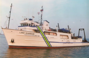
The Lake Guardian - Triaxus and Sea Bird sensors.
U.S. Environmental Protection Agency
The EPA Great Lakes National Program Office (GLNPO) has been collecting wet chemistry samples from multiple locations throughout the Great Lakes region for many years. The subset of the data made available through the Sea Grant GeoDashboard includes:
Phase I - Seasonal aggregations for data collected during the Spring and Summer seasons.
- GLNPO Water Quality Monitoring Stations throughout the Great Lakes where water samples are collected, analyzed with results representing the average value over the multiple sample depths. The data types include:
- Total phosphorous (TP)
- Chlorophyll a (Chl-a)
- Silica
- Nitrogen
- Integrated Atmospheric Deposition Network (IADN) - Air quality data collected since the early 1990s presented as annual aggregations from seven sites and includes data for:
- PCBs vapor
- Endosulfans vapor
- Chlordanes vapor
- DDTs vapor
- DDTs precipitation
- Dieldrin vapor
- Dieldrin precipitation
- Great Lakes Fish Monitoring and Surveillance Program (GLFMSP) - fish collected on an annual basis and analyzed for contaminants that include:
- Mercury (Hg)
- PCB total
- DDT total
- Toxaphene total
- Chlordanes total
- Dieldrin
- Mirex
Phase II - Additional data and activities being added to the system
- PH from wet chemistry data
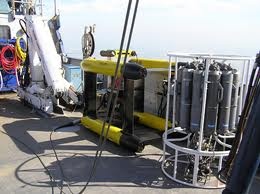
- Seabird - A sensor array that collects data from electronic sensors and physical water samples from the vertical water column at specific locations throughout the Great Lakes.
TRIAXUS - A sensor array that collects data as it's towed behind the ship.
Algorithm Research - In addition to adding new data sources we're researching algorithms and workflows to automate processes that identify data characteristics, patterns and associations to generate derived data products. For example, define the thermocline and photic zone from the raw data using a standard approach.
USGS
Phase I - Sediment discharge data from gauge stations for five principle rivers feeding the Great Lakes since the 1980s.
- St. Louis River at Scanlon, MN (USGS-04024000)
- St. Joseph River at Niles, MI (USGS-04101500)
- Saginaw River at Saginaw, MI (USGS-04157000)
- Maumee river at Waterville OH (USGS-04193500)
- Oswego River at Lock 7, Oswego NY (USGS-04249000)
Phase II - Additional USGS data as requested by the user community.
Other Agency Data
Lake Erie Forage Task Group Station
Data provided by scientists from state, provincial, federal and university agencies conducting research on Lake Erie.
Phase I - Water quality monitoring stations that include near-shore. These water samples were collected over time, analyzed with the result representing the average value over multiple sample depths and include:
- Total phosphorous (TP)
- Chlorophyll a (Chl-a)
Phase II - additional data as requested and provided by the community.
- Add the above data to the new depth profiling tool that will average the values over 1 meter depth increments and make all of the raw data available for download.